|
The Relationship Between Elevation and Surface Pressure on Mars
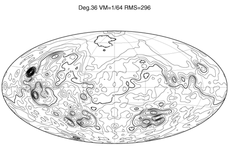
In order for landers to land safely on Mars they need a layer of atmosphere of "sufficient thickness" to descend through. In order to assist in targeting of landers, we are determining the position of the 6.1-mbar atmospheric pressure surface on Mars with respect to surface topography. This analysis is done through a combined analysis of radio occulations and altimetry. Here's how it works. Radio occultation measurements come from Doppler tracking as the signal from an orbiting or flyby spacecraft is lost (ingress) behind a planet and then re-acquired (egress) as viewed from Earth. The change in the frequency and intensity of the radio signal as it traverses through the atmosphere near the planetary limb provides measurements of atmospheric pressure and temperature as function of altitude above the surface. If the position of the spacecraft with respect to Mars' center of mass is known, the timing of the loss (for ingress) and acquisition (for egress) of the radio signal provides measurements of planetary radius. The extinction of the radio signal then provides a measure of atmospheric pressure. Radio occultations thus provide a unique basis for relating planetary radius and atmospheric pressure. By subtracting the geoid from the radius measurements we obtain the elevation from the occultation radii. We want to relate the elevations from the occultations, which have an associated pressure, to the very accurate elevations from our altimeter, MOLA. For a pilot study using Mariner 9 and Viking 1 and 2 Orbiter occultations, we have shown that the MOLA and occultation elevations are indistinguishable within error bounds. The close correspondence of MOLA elevations to those determined by pressure sensors on surface landers provides an independent check of the relationship of MOLA data to surface pressure. With data from Mars Global Surveyor coming in, our understanding of the shape of Mars is evolving on a rapid basis. Below we show a long wavelength model for Mars' shape that has admittedly been superceded by our global topographic model from MOLA, but illustrates how radius measurements derived from occultations can be used to map planetary shape. The figure is a 36th degree and order spherical harmonic model that includes MOLA data in the northern hemisphere, Earth-based radar data in the equatorial region, and occultation radii from Mariner 9, Viking, and the MGS Radio Science Experiment in the southern hemisphere.
Spherical Harmonic Model of Mars Topography. From Smith, D.E., M.T. Zuber and G.A. Neumann, LPSC, XXX, 1999. This was the best topographic model of Mars for about a month (mid-January through February, 1999). Given a close agreement in planetary shape from the altimeter and occultations, we can finally can bring in the atmospheric pressures from the occultations. 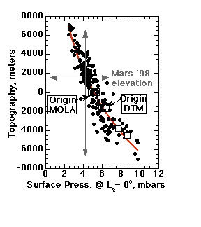
The figure to the leftshows a surface pressure-elevation relationship derived from MOLA topography and Viking and Mariner 9 occultations. Plotted as filled circles are ingress occultations only. Unfilled squares correspond to the Viking 1 & 2 and Pathfinder landing sites. The plot also shows the zero elevation points of MOLA topography and the USGS Digital Terrain Model, the 6.1-mbar atmospheric pressure surface and the expected pressure at the Mars Surveyor '98 landing site. Note that because the pressure changes with the seasons on Mars we must derive the relationship between elevation and pressure at a specific time. In the figure above, we chose the reference point to be the vernal equinox in the northern hemisphere (Ls=0°). The details of this study are discussed in: We must then do a correction for seasonal pressure changes. We are currently using General Circulation Model simulations to estimate the magnitudes of these changes but we are in the process of starting to analyze occultations from Mars Global Surveyor which is observing Mars through its seasonal cycle. Ultimately we hope to combine GCM models and observed surface pressures from the occultations to obtain better estimates of seasonal changes in Mars' surface pressure. A paper that discusses the General Circulation model simulations of the seasonal changes in atmospheric pressure is: Models of the topography and gravity of Mars prior to MGS are available via anonymous ftp to tharsis.gsfc.nasa.gov in the /pub directory. The models are described in: Smith, D.E., F.J. Lerch, R.S. Nerem, M.T. Zuber, G.B. Patel, S.K. Fricke, and F.G. Lemoine, An improved gravity model for Mars: Goddard Mars Model-1: J. Geophys. Res., 98, 20,871-20,889, 1993. Smith, D.E., and M.T. Zuber, The shape of Mars and the topographic signature of the hemispheric dichotomy: Science, 271, 184-188, 1996. REFERENCES Glatzmaier, G., and P.H. Roberts, Rotation and magnetism of Earth's inner core, Science, 274, 1887-1890, 1996. Kuang, W., and J. Bloxham, A numerical model of the generation of the Earth's magnetic field, Nature, 365, 371-374, 1997. Kuang, W., and J. Bloxham, Numerical modeling of magnetohydrodynamic convection in a rapidly rotating spherical shell: Weak and strong field dynamo action, J. Comp. Phys., 153, 51-81, 1999. Stevenson, D.J., Mars' core and magnetism, Nature, 412, 214-219, 2001. |
 |
 |